北极海冰缩减至2026年度最小范围 - NASA科学
Arctic Sea Ice Shrinks to Its 2026 Minimum - NASA Science
以下为原文逐段中文翻译,保留图表与说明。AI 翻译并经 AI 对照复核,仍可能存在错误;核对数据和引用时请同时查看原文。译文发布:2026年10月7日 19:24(北京时间)。
本文是对我们“变化中的世界”系列中北极海冰专题的一次更新,该系列通过卫星影像追踪地球表面的长期变化。
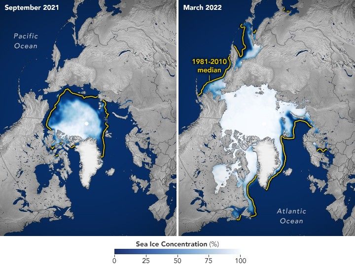
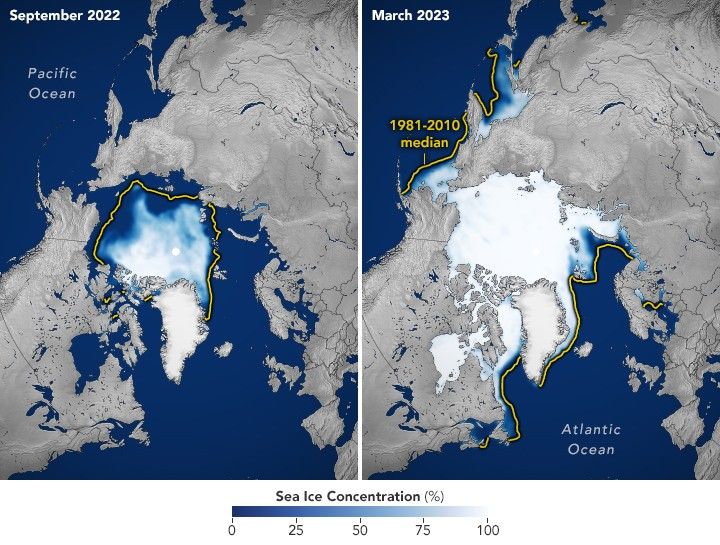
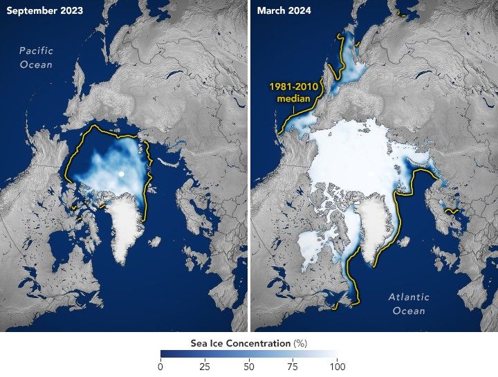
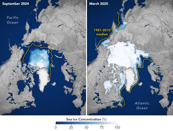
北冰洋表面覆盖着一层冻结的海水。这些海冰在漫长的极地冬季不断增长,通常在3月达到最大范围,随后在夏季融化,于9月降至年度最小范围。这种自然波动已经持续了数千年。但卫星记录显示,与几十年前相比,如今海冰在年度最大和最小范围时覆盖的北冰洋面积都更小了。
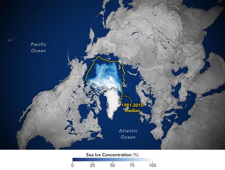
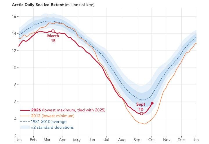
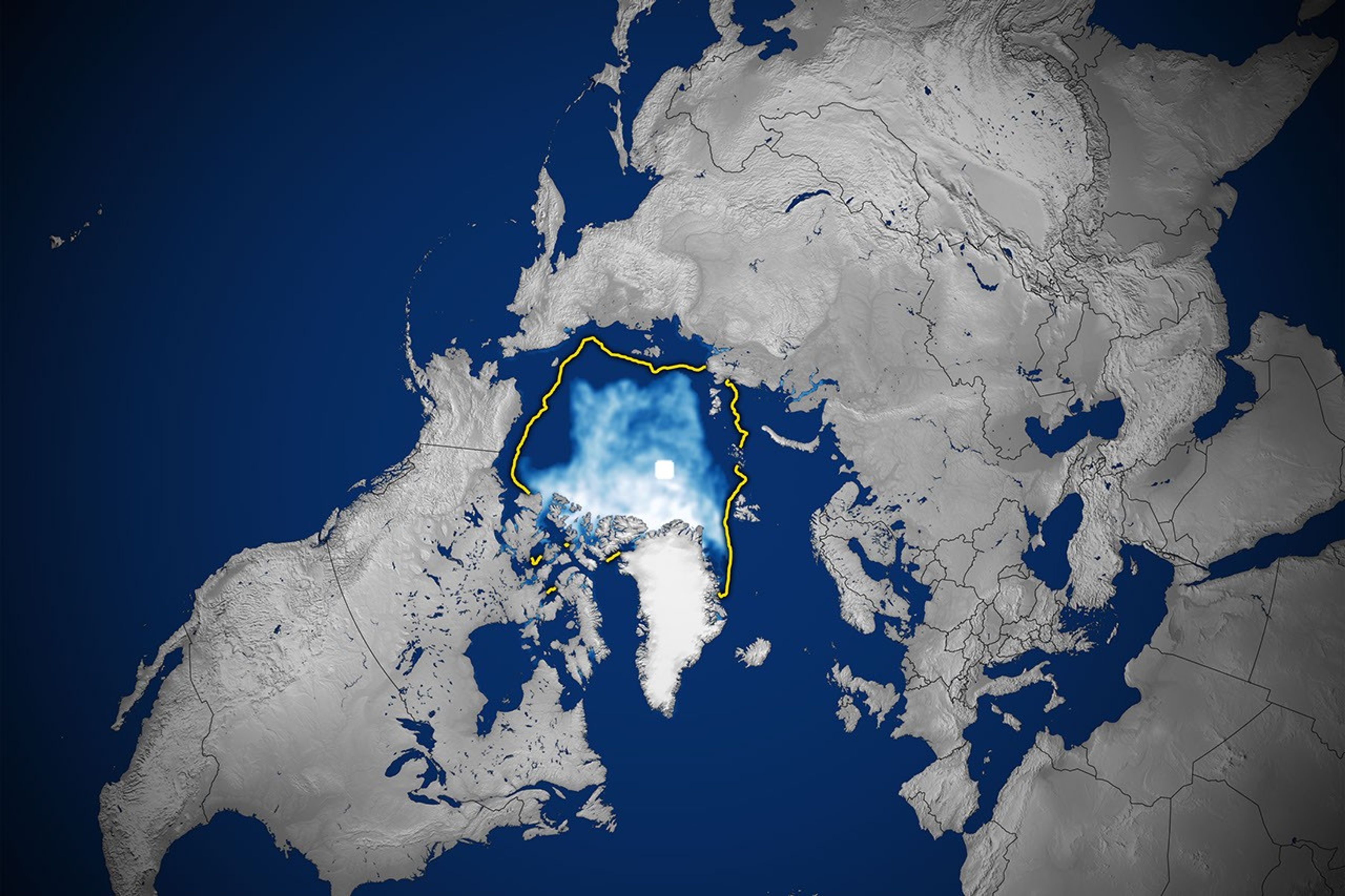
据NASA和美国国家冰雪数据中心(NSIDC)介绍,2026年的海冰于9月12日达到年度最小覆盖范围(见上图),当时的覆盖面积估计为460万平方千米(178万平方英里)。这一数值与2008年、2010年和2025年并列,为卫星记录中第10低的年度最小值。
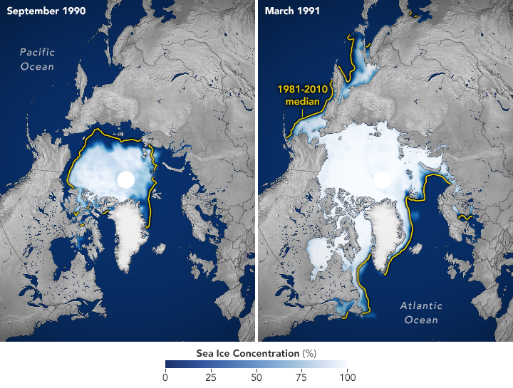
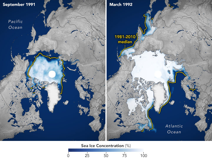
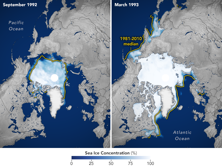
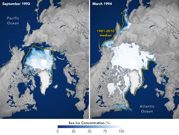
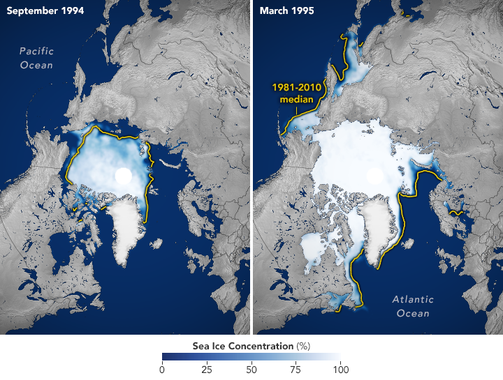
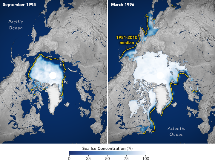
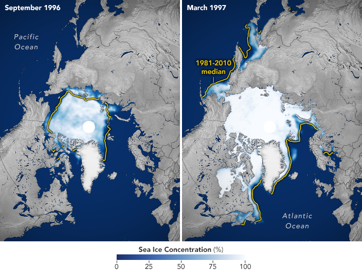
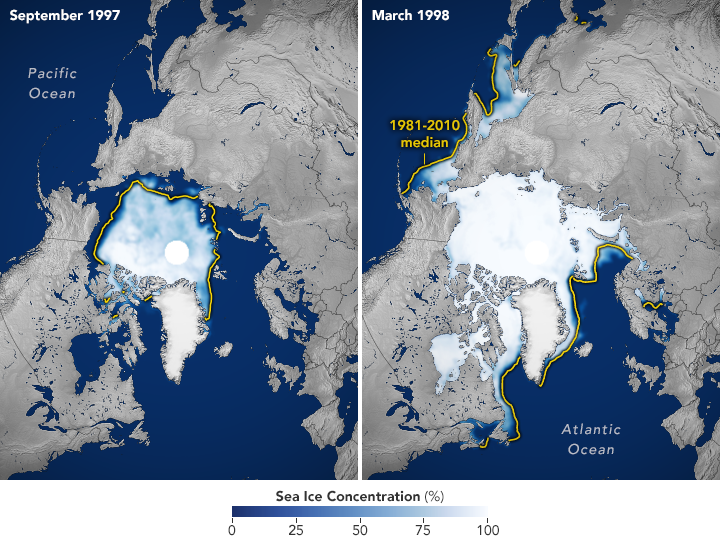
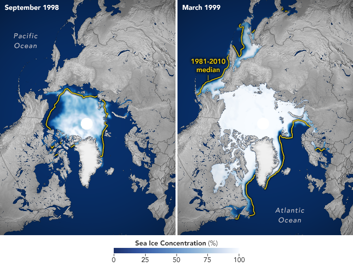
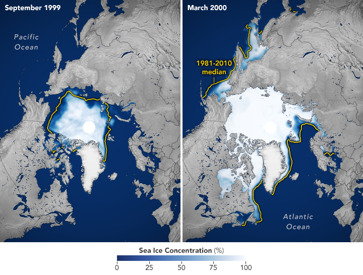
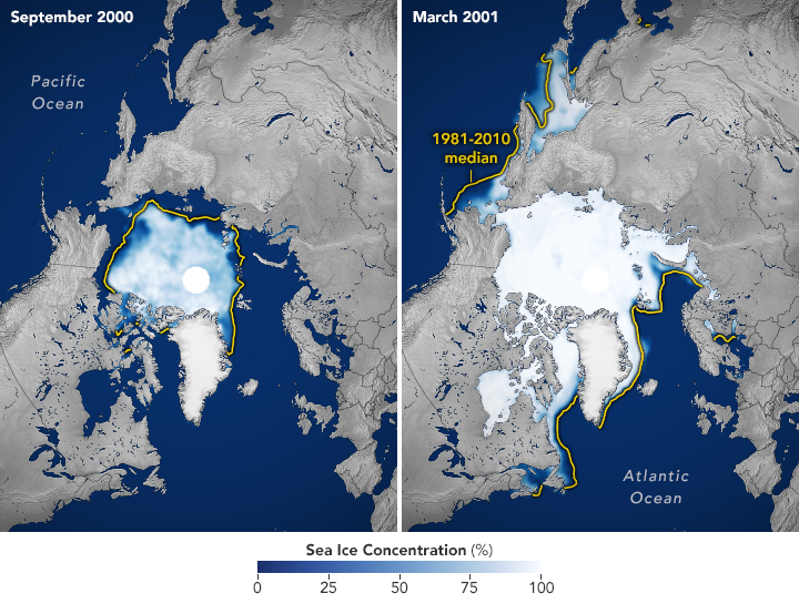
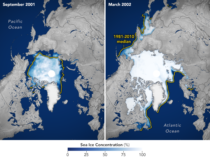
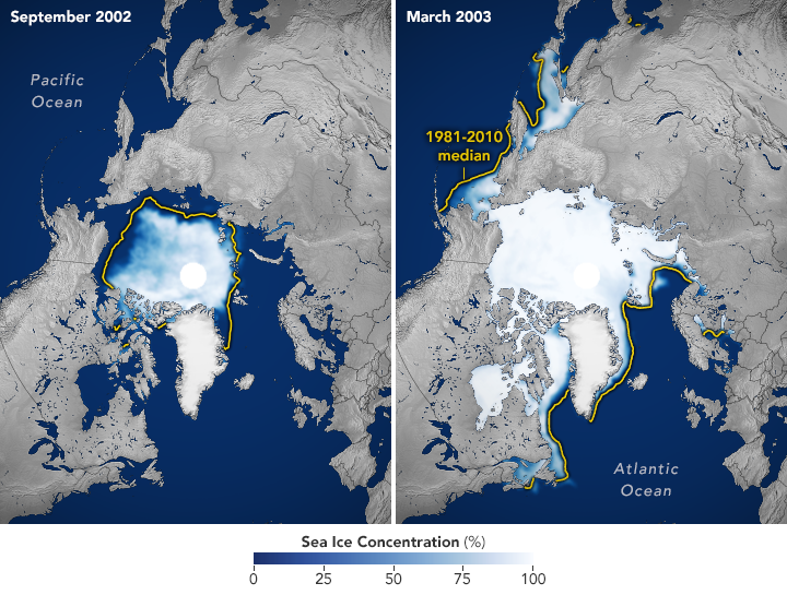
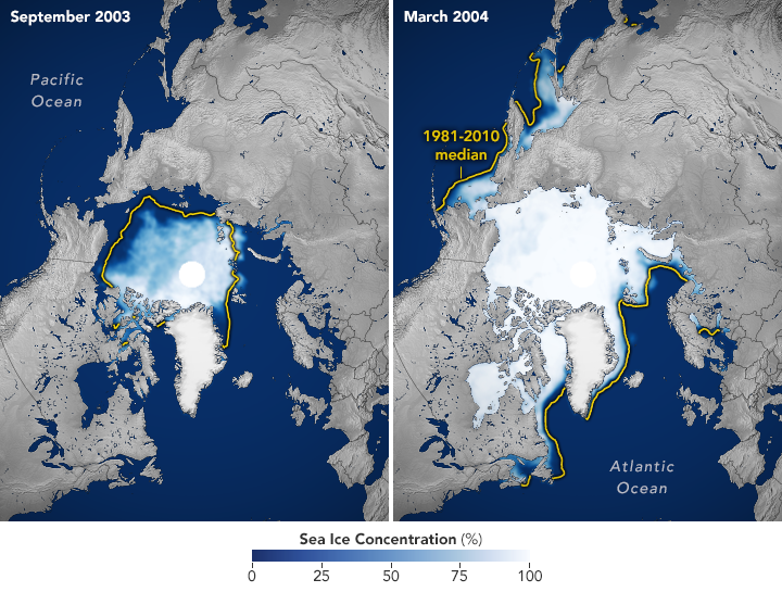
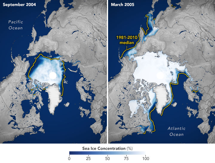
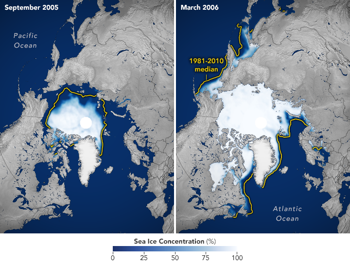
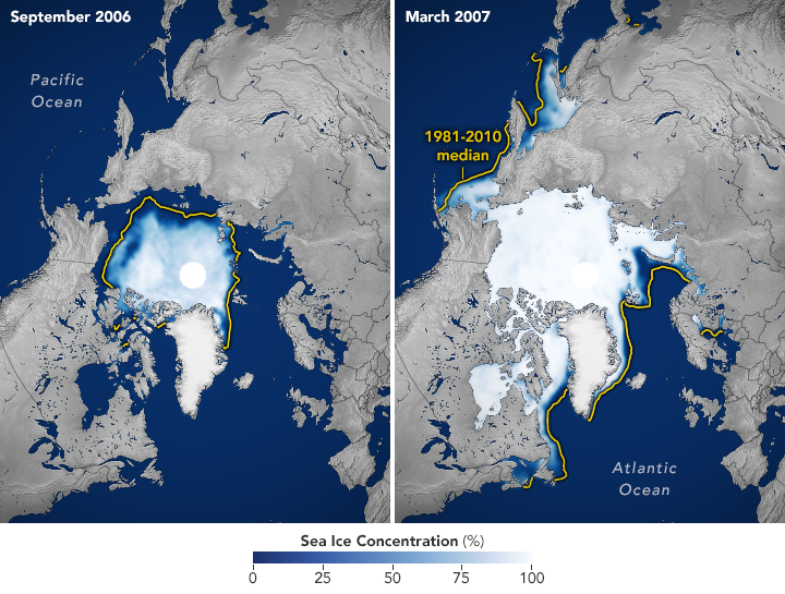
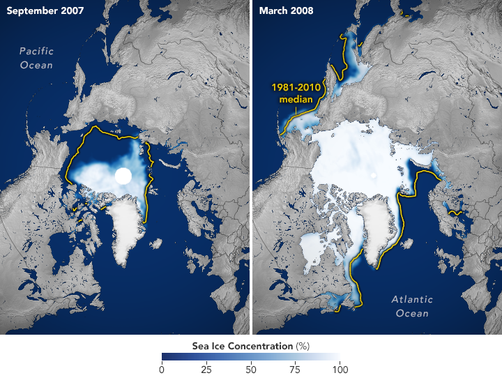
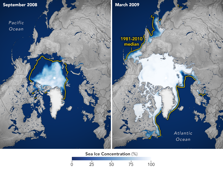
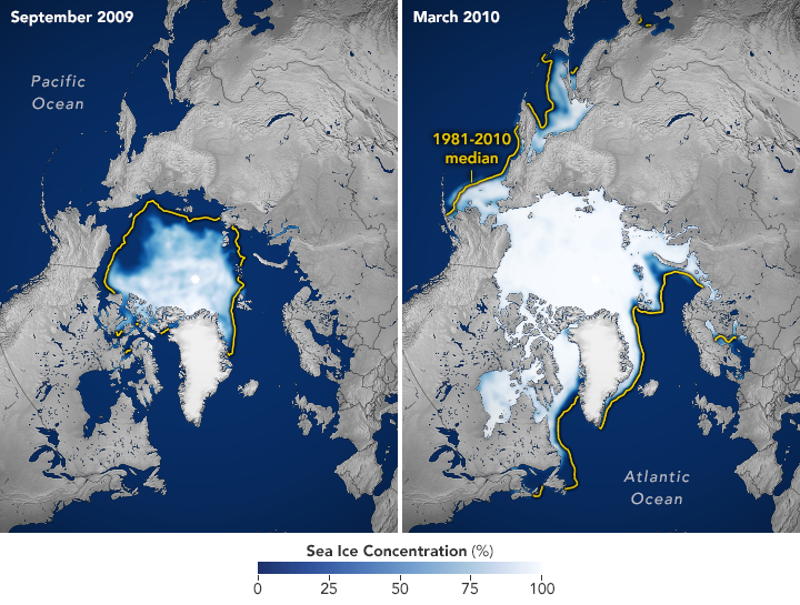
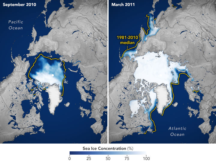
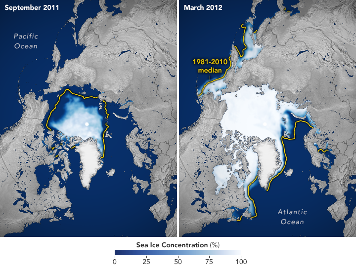
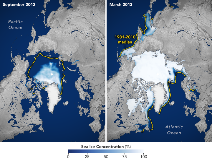
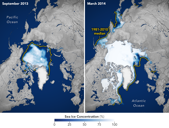
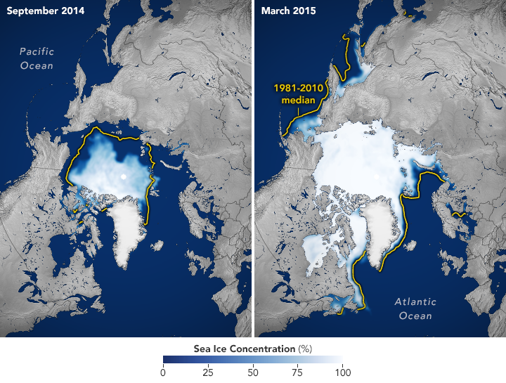
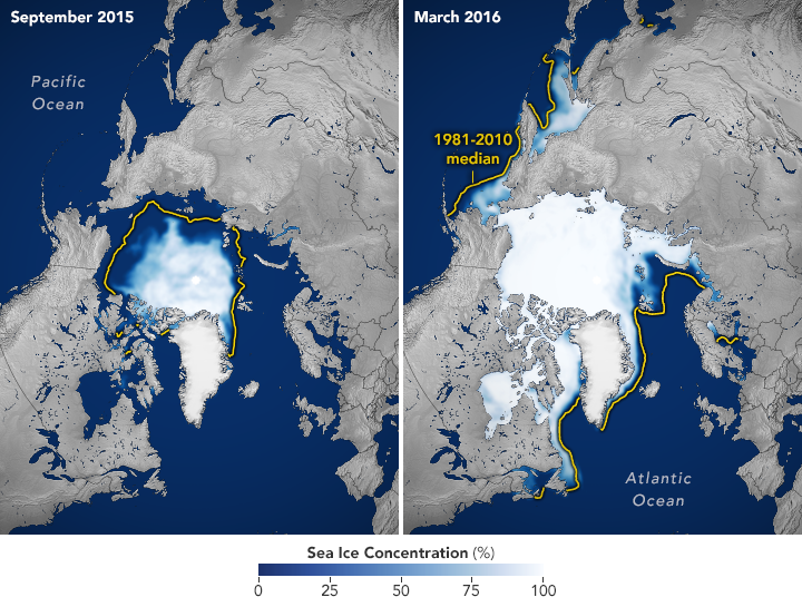
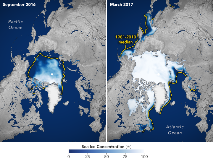
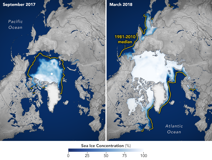
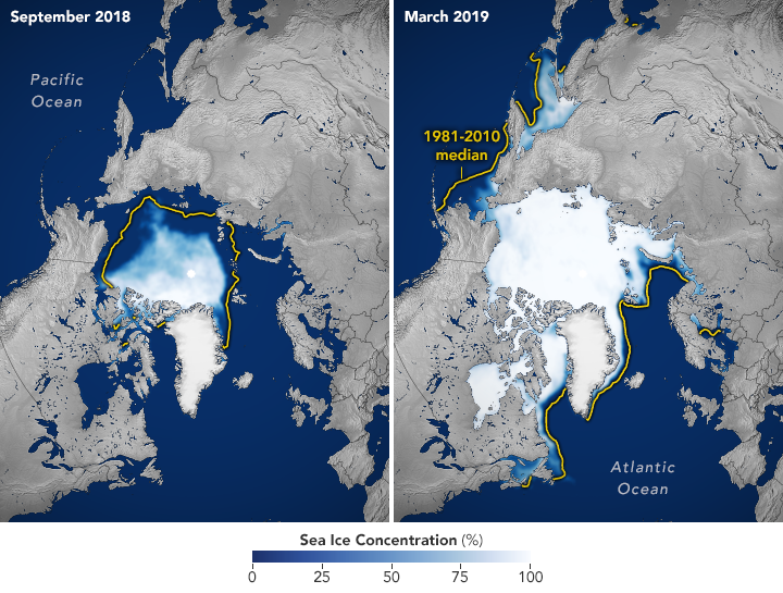
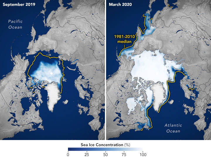
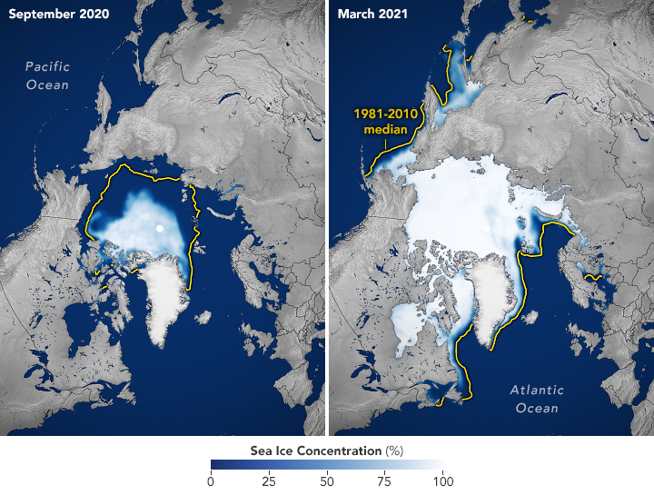
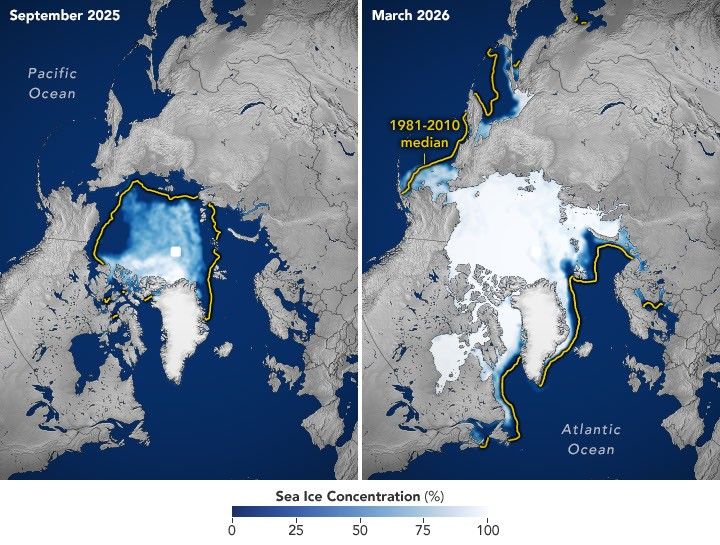
下方的地图将1990年以来每年9月、即海冰接近年度最小范围时的情况(左图),与次年3月、即接近年度最大范围时的情况(右图)配对展示,一直延续到2026年3月。
最小范围更小,海冰更薄
自1978年末以来,科学家一直利用卫星持续观测北极海冰每年的增长和消退。在此期间,海冰覆盖范围总体上有所缩小,而在2000年代,下降趋势加剧,接连出现创纪录或接近纪录的低值。过去20个夏季,即2007年至2026年,每一年的海冰最小覆盖范围都位列卫星记录中的20个最低值之中。最低值出现在2012年9月。
最近一段时期,9月的海冰覆盖范围相对稳定。天气会使不同夏季的海冰融化量出现很大差异。例如,据NASA科学家介绍,过去十年中,云量的增加阻止了阳光加速海冰融化。尽管最近出现了这一趋于平稳的阶段,夏季最小覆盖范围仍远低于长期平均水平。
在整个北极地区,现存海冰的冰龄更短,厚度更薄。观测显示,多年冰——即至少经历过一个融化季后仍未消融的海冰——正在减少,北极因而以较薄的一年冰为主。冬季海冰也在缩减。2026年3月的海冰最大覆盖范围在统计意义上与2025年的最大值并列,为卫星记录中的最低值。
已知北极涛动等自然变率周期会影响北极海冰覆盖范围,但整个卫星记录期间观测到的缩减趋势,无法仅用自然变率来解释。自然变率和全球气温上升共同作用,使更多北极海冰融化。科学家预测,在21世纪中叶之前,北极可能至少出现一次基本无冰的状况。
穿透云层观测
为了确定海冰覆盖范围,科学家依靠搭载被动微波传感器的卫星,这些传感器测量地球自然发射的微波能量。海冰发射的这类能量比无冰水面更多,因此在微波影像中清晰可辨。由于微波能够穿透云层,无论天气如何,卫星都能定期观测海冰。
这项记录始于1978年,最初采用NASA的Nimbus-7卫星采集的数据,随后从1987年起使用国防气象卫星计划(DMSP)的卫星数据,并在2002年至2011年间使用NASA的Aqua卫星数据。自2025年起,科学家开始使用日本宇宙航空研究开发机构GCOM-W卫星的观测数据。每幅图像中心的白色圆圈是“极地空洞”,卫星传感器历来无法采集圆圈边界以北区域的数据。海冰估算以该空洞完全被冰覆盖为假设。
NASA Earth Observatory图像由Michala Garrison制作,使用了美国国家冰雪数据中心的数据。
下载
2026年9月12日
JPEG(3.32 MB)
参考文献与资源
- IPCC(2021年)。《决策者摘要》。载于《气候变化2021:自然科学基础》——政府间气候变化专门委员会第六次评估报告第一工作组报告。访问日期:2026年10月6日。
- NASA Earthdata(2026年10月)。《海冰》。访问日期:2026年10月6日。
- NASA Earth Observatory(2026年10月6日)。《变化中的世界:北极海冰》。访问日期:2026年10月6日。
- NASA Earth Observatory(2016年9月16日)。《海冰》。访问日期:2026年10月6日。
- NASA Earth Science(2026年9月23日)。《北极海冰达到2026年度最小覆盖范围》。访问日期:2026年10月6日。
- 美国国家冰雪数据中心(2026年9月23日)。《北极海冰最小覆盖范围并列第十低》。访问日期:2026年10月6日。
- 美国国家冰雪数据中心(2026年3月26日)。《北极海冰最大覆盖范围再次降至历史最低值》。访问日期:2026年10月6日。
展开英文原文 · 与中文逐段对应
Arctic Sea Ice Shrinks to Its 2026 Minimum - NASA Science
This story is an update to the Arctic sea ice feature in our World of Change series, which tracks long-term change on Earth's surface through satellite imagery.
A layer of frozen seawater caps the Arctic Ocean. This sea ice grows through the long polar winter, usually peaking in March, then melts through the summer to its annual low in September. It is a natural fluctuation that has persisted for millennia. But satellite records show the ice now covers less of the Arctic Ocean at its annual maximum and minimum than it did a few decades ago.
Sea ice in 2026 reached its annual minimum extent on September 12 (above), when it covered an estimated 4.6 million square kilometers (1.78 million square miles), according to NASA and the National Snow and Ice Data Center (NSIDC). That ties 2008, 2010, and 2025 for the 10th-lowest minimum in the satellite record.
The maps below pair each September since 1990 (left), around the ice's annual minimum, with the following March (right), near its annual maximum, through March 2026.
Lower Lows, Thinner Ice
Scientists have used satellites to observe the annual growth and retreat of Arctic sea ice continuously since late 1978. While sea ice extent has declined overall during that time, the downward trend steepened in the 2000s and set off a run of record and near-record lows. Each of the past 20 summers, from 2007 through 2026, ranks among the 20 lowest minimum extents in the satellite record. The lowest occurred in September 2012.
More recently, the September sea ice extent has been relatively steady. Weather can make a big difference in how much ice melts from one summer to the next. For example, over the past decade, increased cloud cover has prevented sunlight from accelerating the melt , according to NASA scientists . Despite this recent plateau, the summer minimum remains well below the long-term average.
Across the Arctic, the ice that remains is younger and thinner . Observations show a decline in multiyear ice—that which survives at least one melt season—leaving an Arctic dominated by thinner first-year ice . Winter ice is also shrinking. The March 2026 maximum statistically tied the 2025 maximum for the lowest in the satellite record.
Cycles of natural variability such as the Arctic Oscillation are known to play a role in Arctic sea ice extent, but the decline observed throughout the satellite record cannot be explained by natural variability alone. Natural variability and rising global temperatures have worked together to melt greater amounts of Arctic sea ice. Scientists have projected an essentially ice-free Arctic could occur at least once before the middle of the 21st century.
Seeing Through the Clouds
To determine sea ice extent, scientists rely on satellites with passive microwave sensors that measure the microwave energy Earth naturally emits. Sea ice emits more of this energy than open water, so it stands out in microwave images. Because microwaves pass through clouds, the satellites can observe sea ice regularly, regardless of weather.
The record began in 1978 with data collected by NASA’s Nimbus-7 , followed by Defense Meteorological Satellite Program (DMSP) satellites starting in 1987 and NASA’s Aqua satellite between 2002 and 2011. Starting in 2025, scientists began using observations from the Japan Aerospace Exploration Agency’s GCOM-W satellite . The white circle at the center of each image is the “pole hole,” north of which satellite sensors have historically been unable to collect data. The sea ice estimates assume that this hole is ice-filled.
NASA Earth Observatory images by Michala Garrison, using data from the National Snow and Ice Data Center.
Downloads
September 12, 2026
JPEG (3.32 MB)
References & Resources
- IPCC (2021) Summary for Policymakers. In: Climate Change 2021: The Physical Science Basis. Contribution of Working Group I to the Sixth Assessment Report of the Intergovernmental Panel on Climate Change. Accessed October 6, 2026.
- NASA Earthdata (2026, October) Sea Ice. Accessed October 6, 2026.
- NASA Earth Observatory (2026, October 6) World of Change: Arctic Sea Ice. Accessed October 6, 2026.
- NASA Earth Observatory (2016, September 16) Sea Ice. Accessed October 6, 2026.
- NASA Earth Science (2026, September 23) Arctic Sea Ice Reaches 2026 Annual Minimum Extent. Accessed October 6, 2026.
- National Snow and Ice Data Center (2026, September 23) Arctic sea ice minimum ties for tenth lowest. Accessed October 6, 2026.
- National Snow and Ice Data Center (2026, March 26) Arctic sea ice record low maximum strikes again. Accessed October 6, 2026.
信息从哪里来
- NASA 新闻发布 原始来源